Ocean currents at the Viet Nam East Sea – Eng. Doan Manh Dung
Ocean currents affect seaport planning and create new jobs that use the kinetic energy of ocean currents to generate electricity and electrolyze liquid hydrogen.
1 North-South bottom ocean currents
1.1 Detecting North-South bottom ocean currents by experiment
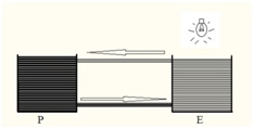
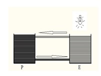
Figure 1: Experimental model to detect North-South bottom ocean currentsMake two flasks P and E with wide mouths and different colored water. Use two colorless tubes. One pipe connects the water layer above the two flasks, the other connects the water at the bottom of the two flasks.When shining the light on the open surface of flask E, then there is a heat difference, a surface flow from E to P and bottom flow from P to E occurs.
Experiment results:
a/ The velocity v of the circulating current does not change on the path from E to P and from P to E.
b/ When the lamp temperature is increased on the open surface E, the velocity v of the circulating current increases.
Consequence :
a/ We consider E as the Equator region, P as the polar region. Because there is a thermal difference between the Equator and the Pole, a convection current appears as an experiment. Thanks to this experiment, we know that there is a bottom ocean current moving at the bottom of the sea from the Pole tu Equator.
b/ Because the earth rotates from West to East, the bottom-floor circulation moves from East to West due to the action of the Coriolic force of inertia.
c/ Summarizing the north-south and east-west movements of the bottom ocean currents, which are factors affecting marine economic planning in Vietnam.
1.2 Characteristics of the bottom ocean currents
The North-South bottom line is formed and moves in the rotation of the earth, so it is affected by the Corioloic force.
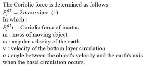
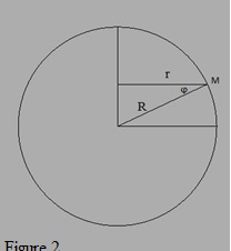

Figure 3.
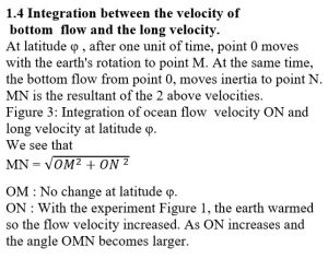
With formula (1) we see:The North-South bottom flow is maximum when it originates near the earth’s poles and gradually decreases to zero when the North-South current occurs near the Equator.
Consequences: The earth warming will cause erosion of the East Coast of VietNam to create a new balance. MN is maximum when:
a/ Maximum OM – near the Equator according to formula (2)
b/ Maximum ON- when the ocean flow occured near the poles according to formula (1) Central Vietnam meets both of the above factors, so it is the place to receive many energy sources of the earth.
1.5 Practicality
On October 18th, 2010, passenger bus 48K-5868 on route Dac Nong – Nam Dinh crashed into Lam river – Ha Tinh, about 32km from the sea mouth. Many dead. In which, 4 bodies drifted to the estuary and were brought to the Southern coast by currents. No bodies drifted North.
2. Formation of North-South surface ocean currents in the East Sea coast of Vietnam
This current is formed by the northeast’s wind in 8 months/year. Documents on surface ocean flow are well common and widely used in Vietnam’s marine navigation.
3. Applications
3.1 North-South bottom and surface ocean currents in the East Sea are special factors affecting economic planning in coastal areas of Vietnam.
Due to the fact that the earth rotates from west to east, the ocean currents formed by the heat difference in the east coast of Vietnam have a strong impact on the coast, causing sedimentation and maritime accidents. This feature is not found on the European coast. Therefore, caution should be exercised when bringing the European experience to Vietnam’s shores.
3.2 The bays on the East coast of Vietnam with the mouth of the bay looking to the south can resist the ocean currents bringing alluvium into the bay.
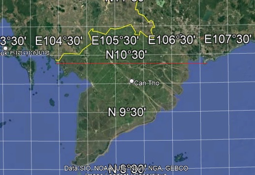
When locating a seaport on the east coast of Vietnam, in addition to avoiding the use of estuary waters that bring alluvium from the Truong Son mountain range into the seaport waters, we also choose a bay with a south-facing estuary to avoid the North-South current that brings alluvial to the port. On this principle, it is determined that Van Phong bay, Cam Ranh bay and Vung Ro bay have stable depths for long-term exploitation.
3.3 Phenomenal nature of dynamic sea channel at Dinh An river gate.
Studying the North-South bottom flow and the North-South surface flow have clearly shown the phenomenal nature of dynamic sea channel at Dinh An river gate. During the flood season, the flow rate created Dinh An channel at the sea mouth. In winter, the resonance of surface and bottom ocean currents pushes Dinh An sea channel to move south. Thus, the Dinh An channel moves according to the annual cycle. On this basis, we have proposed Tran De gateway port for the Mekong Delta.
3.4 The North-South current in central Vietnam is a rare and precious energy resource of the country.
The ocean currents in the Central region is a rare phenomenon in the world. This is a valuable energy source of the country. We are pround of discovering a new technology from Vietnam that can reduce the weight of objects rotating in water and can receive maximize the kinetic energy along the depth and width of the flow to produce electricity at a competitive price. From that, we can creat new jobs in producing electricity generation and liquid hydrogen electrolysis for people in Central Vietnam.
3.5 It is necessary to prevent accidents when traveling to the beach or doing sea sports in Central Vietnam.
Strong currents in Central Vietnam are dangerous for beach tourism in Central Vietnam. Therefore, it is necessary to take precautions to avoid accidents./.